

What's New!
Detailed Sitemap
All images © by Roberto Piperno, owner of the domain. Write to romapip@quipo.it. Text edited by Rosamie Moore.
Page added in November 2013.
|

 - Jerash - page two - Jerash - page two
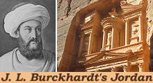
(left: J. L. Burckhardt in Arab attire in a XIXth century engraving; right: the Treasury of Petra)
If you came to this page directly you might wish to read page one first.
Southern Gate - out of plan
On this side of the town there are no other ruins of any consequence, excepting the south-west gate, which is about five minutes walk from the semicircle of columns: it is a fine arch, and, apparently, in perfect preservation, with a smaller one on each side adorned with several pilasters. I did not examine it closely; meaning to return to it in taking a review of what I had already seen, but my guides were so tired with waiting, that they positively refused to expose their persons longer to danger, and walked off, leaving me the alternative of remaining alone in this desolate spot, or of abandoning the hope of correcting my notes by a second examination of the ruins.
Nymphaeum - m in the plan
Returning from the theatre, through the long street, towards the four cubic pedestals, I continued from thence in a straight line along the main street (l), the pavement of which is preserved in several places. On the right hand, were first seven columns, having their entablatures; and farther on, to the left, seven others, also with their entablatures; then, on the right, three large columns without entablatures, but with pedestals, which none of those already mentioned have; opposite to the latter, on the left hand side of the street, are two insulated columns.(..) The columns are equal in size to those of the peristyle of the temple (a); they stand in the same line with the colonnade of the street, and belonged to a small building (m), of the body of which nothing remains except the circular back wall, containing several niches, almost in complete ruins.
The building with the circular back wall was a nymphaeum, a monumental fountain, the niches of which most likely housed statues. Other statues were kept inside the temples or embellished the theatres of ancient Jerash, yet archaeologists have not found them. They were most likely smashed in 435 AD when Emperor Theodosius II issued a decree ordering the destruction of pagan temples and symbols or in the following centuries by the Muslims who regarded statues as idols. However in many other ancient towns in the Levant not all statues were destroyed.
Macellum (marketplace)
On his way from the oval square to the four cubic pedestals, Burckhardt did not notice the ruins of a small covered marketplace which has been reconstructed. A fountain was situated at the centre of the building, not just as an embellishment, but because meat and other food were sold in the market. It had a round shape which recalls the macellum of Leptis Magna in Libya.
Propylaea (grand entrance to a temple or sacred area) - n in the plan
The street is here choked up with fragments of columns. Close to the three columns stands a single one, and at a short distance further, to the left, is a large gateway (n), leading up to the temple (a), which is situated on considerably higher ground, and is not visible from the street.
The Temple to Artemis was preceded by an imposing entrance on the main street. The tips of the columns which supported the tympanum of the temple are visible from the street, but maybe when Burckhardt visited Jerash the view was impaired by ruined walls or columns.
Propylaea - details
The gateway dates circa 150 AD and its elaborate carvings are evidence of the attention to details which characterizes the monuments of this period throughout the whole Roman Empire. It coincided with the reign of Emperor Antoninus Pius, an unparalleled period of peace and prosperity.
With such care did he govern all peoples
under him that he looked after all things and all men
as if they were his own. As a result, the provinces
all prospered in his reign.
Scriptores Historiae Augustae - Antoninus Pius VI; 7; VII - Translation by David Magie.
The image used as background for this page shows another detail of the Propylaea decoration.
Columns in the northern section of Cardo Maximus - q in the plan
Continuing along the main street, I came at (q), to a single column, and then to two with entablatures, on the right; opposite to them, on the left, are three single columns. Beyond the latter, for one hundred paces, all the columns have fallen.
Because many columns have been re-erected it is not easy to identify the single column Burckhardt indicated with q in the plan. However the long stretch of Cardo Maximus without columns is still noticeable.
Rotunda - r in the plan
I then came to an open rotunda (r), with four entrances.
You can see the rotunda as it was in 1812 in an old photograph (it opens in a separate page). The rotunda was dedicated to Julia Domna, wife of Emperor Septimius Severus, of Syrian origin. The current building is a case of excessive reconstruction.
Corinthian columns - s in the plan
I followed this cross street to my left, and found on the right hand side of it three short Ionic pillars with their entablatures, close to the rotunda. Proceeding in the same direction I soon reached a quadrangle (s) of fine large Corinthian columns, the handsomest in the town, next to those of the temple. To the right stand four with their entablatures, and one single; formerly they were six in number, the fifth is the deficient one: the first and sixth are heart-shaped, like those in the area of the temple (a).
Luckily nothing has changed in this group of Corinthian columns. They most likely were one side of a square portico.
Northern Theatre - t in the plan
This colonnade stands in front of a theatre (t), to which it evidently formed an appendage. This theatre is not calculated to hold so many spectators as the one already described though its area is considerably larger, being from forty-five to fifty paces in diameter. It has sixteen rows of benches, with a tier of six boxes intervening between the tenth and eleventh rows, reckoning from the top. Between every two boxes is a niche, forming a very elegant ornament. This theatre was evidently destined for purposes different from the other, probably for combats of wild beasts, etc.; the area below the benches is more extensive, and there is a suite of dark arched chambers under the lowest row of seats, opening into the area near the chief entrance of the theatre, which is from the south-east, in the direction by which I entered the colonnade in front of the theatre.
Northern Theatre - details: (left) the seating section; (right) reliefs indicating that the theatre was used for poetry contests and music
The theatre was built during the reign of Emperor Marcus Aurelius (Antoninus Pius' successor) most likely to be used as a odeon, a covered hall for poetry contests and music as indicated by the reliefs (and not for combats of wild beasts as Burckhardt supposed). It was then enlarged to house assemblies because some of the seats appear to have been reserved to members of religious or political groups.
Ionic columns - v in the plan
Having returned from hence to the rotunda in the long street, I followed it along the colonnade (v) and found the greater number of the columns to have Ionic capitals. On the right side are only two small columns, with their entablatures; to the left, are eight, two, three, two, four, and again three, each set with their entablatures.
Cardo Maximus, the long north-south street of Jerash, was flanked by columns along all its length. Such colonnades are typical of some ancient towns in this part of the Roman Empire, the longest ones being those of Apamea and Palmyra.
Northern Gate - w in the plan
Close to the ruined town-gate (w), near the bank of the river, is a single column.
The "ruined town-gate" is now an imposing building, but you might be interested to see it as it was when Burckhardt visited Jerash (it opens in a separate page). The Northern Gate was built in 115 AD. It clearly had only a celebratory purpose, because it was not protected by side towers. At that time Emperor Trajan had expanded the Roman Empire to the Persian Gulf and there was no fear of enemies threatening Jerash.
Northern baths - u in the plan
I shall now describe the ancient buildings, which I observed on the south-west side of the long street. The street which leads from the theatre across the rotunda (r) is prolonged from thence towards the side of the river: it was lined with columns, of which two only, with their entablatures, remain, and it terminates at a vast edifice (u), situated over the river, and extending along its banks forty or fifty paces; it is divided into many apartments, the greater part of which have arched roofs; some of them are very lofty.
The complex of buildings has turned out to be one of the two large public baths of the town.
Street opposite the Propylaea - o in the map
I now returned towards the gateway (n), and found, opposite to it, and to the great temple (a), a second cross street (o) running towards the river; it had originally a colonnade, but none of the columns are now standing; it terminates, at about thirty paces from the main street, in a gate, through which I entered into a long quadrangle of columns, where, on the right hand, four, and then three columns, with their entablatures, are still standing.
It appears that the short street was turned into a long church. Some of its columns were made of Egyptian granite.
Missing bridge - p in the map
At the end of this place, are the remains of a circular building fronting a bridge (p) across the river: this bridge is of steep ascent, owing to the northern banks being considerably higher than the southern, and it is no longer passable.
The bridge most likely collapsed before the street leading to it was turned into a church. It must have been a viaduct, rather than a simple bridge.
Southern Decumanus towards the southern bridge - i in the plan
Having returned to the four cubical pedestals (d), I followed to the left the continuation of the street (c), by which I had first approached those pedestals, and which having crossed the main street at the pedestals, leads south-westward to the river, where it terminated at a broad flight of steps, leading down to a bridge; of the colonnade of this street (i), some broken shafts only are standing.
Modern Jerash occupies the eastern/southern section of ancient Gerasa on the other side of the small river which crosses the town. A wall marks the limits of the archaeological area, but it is not unusual to meet folks who climb it and trespass.
Bridge - k in the plan - and baths - y in the plan
The bridge (k) is fourteen feet wide, with a high centre arch and two lower ones; it is built with great solidity, and its pavement is exactly of the same construction as that which I observed in the streets of Shohba (Shahba, ancient Philippopolis); its centre is broken down. Nearly opposite to the temple (m), are the remains of a building (y) similar in construction to that marked (u), on the right bank. I supposed it to be a bath; a stream of water descends from a spring in the mountain, and after flowing through this division of the town, passes this building, and empties itself into the river.
A modern bridge has been built on the structures of the ancient one. The baths are now surrounded by modern buildings.
Arch of Hadrian - south of the Southern Gate
I must confess, however, that I did not examine the part of the town towards the south gate; but I have reason to believe, from the view which I
had of it while on the temple hill, that nothing of consequence, either as to buildings or columns, is there to be met with.
How did Burckhardt not notice such an imposing monument? Most simply because it was not there. An image shows an early phase of its reconstruction (it opens in a separate page). Emperor Hadrian visited Gerasa in 129-30 AD and the arch, in addition to celebrating the event, was most likely meant to mark an expansion southwards of the town.
Arch of Hadrian - details: (above) decoration of one of the side windows; (below) parts of a long Greek inscription indicating the purpose of the arch; they show the words autocrator (emperor) kaisar (caesar) and the Greek names of Trajan and Hadrian
While Burckhardt entered Jerash from a minor gate (or just a breach in the walls) near the Temple to Artemis, today's visitors enter it at the Arch of Hadrian and it is understandable that Jordan authorities wanted to immediately give them a feeling of the wealth of ancient Gerasa. As it occurs in so many archaeological sites (e.g. Carthage), authorities find money to finance reconstructions of imposing monuments, but leave parts of the site to rot because they are not regarded as "must see".
Hippodrome - south of the Southern Gate: (above) general view; (below) a section of the seats
The ruins of a hippodrome between the Arch of Hadrian and the Southern Gate have housed in recent years a re-enactement of a chariot race (it opens in a separate page) made popular by Ben-Hur, a 1959 movie starring Charlton Heston and shot at Cinecittà. From what I gathered in October 2013 the initiative did not meet planned economical results and was discontinued.
Details: (left) inscription mentioning Emperor Marcus Aurelius (Museum of Jerash); (right-above) inscription on the Northern Gate; (right-below) a sarcophagus decorated with "pelta", the shield of the Amazons (Museum of Jerash)
In general, museums at archaeological sites in Jordan, including that at the Citadel of Amman, display their exhibits in a rather disappointing way. A new National Museum of Jordan is expected to open by the end of 2013 (see their website - it opens in a separate page).
Goats are in charge outside the "must see" part of the archaeological area
Return to page one or go to Christian Jerash.
Move to:
Introductory Page
Ajlun Castle and Pella (May 3rd, 1812)
Amman and its environs (July 7th, 1812)
Aqaba
"Castles" in the Desert (incl. Qasr el-Azraq)
Madaba (July 13th, 1812)
Mt. Nebo and the Dead Sea (July 14th, 1812)
On the Road to Petra (incl. Kerak and Showbak) (July 14th - August 19th, 1812)
Petra (August 22nd, 1812)
Umm al-Jimal
Umm Qays (May 5th, 1812)

SEE THESE OTHER EXHIBITIONS (for a full list see my detailed index).
  
|


