 What's New! Detailed Sitemap All images © by Roberto Piperno, owner of the domain. Write to romapip@quipo.it. Text edited by Rosamie Moore. Page added in July 2006. |
  - Introduction - Introduction
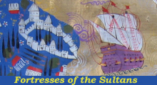
(detail of an Ottoman miniature showing Rumeli Kavagi, a lost fortress on the Bosporus) Towards the end of the XIIIth century the Seljuk sultans, who ruled over central Anatolia, assigned to Osman, the leader of a tribe of Turkoman horsemen, some districts at the border with the Byzantine Empire. It was the first contact between the Ottomans, (latinized version of Osmanli, Osman's descendants) and the western world. Osman and his son Orhan soon realized the weakness of the Byzantines, which was mainly caused by dynastic quarrels. They started a policy of conquest at the expense of minor feudal Byzantine nobles and then moved against Bursa and Nicea, the main Byzantine cities in Anatolia, which were captured in 1326 and 1331. By these additions the Ottoman principality reached the Sea of Marmara. By 1345 Orhan conquered the whole southern coast of that sea, from the Dardanelles to the Bosphorus, two straits giving access respectively to the Aegean Sea and to the Black Sea.  1900 Times Atlas: map of the Marmara Sea: numbers refer to the fortresses listed below
This section shows some of the fortresses built by the Sultans to protect the Marmara Sea which became the very heart of their large empire. The Ottoman leaders were called sultans after 1383, when Murad I declared himself sultan, temporal leader (rather than caliph, a title having a religious connotation). Fortresses built before the conquest of Constantinople (1453): 1 - Anadolu Hisar 2 - Rumeli Hisar Fortresses built after 1453 and before 1657 (major Venetian attempt to enter the Dardanelles): 3 - Kale Sultanieh 4 - Kilitbahir Fortresses built after 1657: 5 - Seddulbahir 6 - Imbro 7 - Tenedo Map of Turkey with all the locations covered in this website     |