Home

Visit Rome following 8 XVIIIth century itineraries XVIIIth century Rome in the 10 Books of Giuseppe Vasi - Le Magnificenze di Roma Antica e Moderna The Grand View of Rome by G. Vasi The Environs of Rome: Frascati, Tivoli, Albano and other small towns near Rome A 1781 map of Rome by G. Vasi An 1852 map of Rome by P. Letarouilly Rome seen by a 1905 armchair traveller in the paintings by Alberto Pisa The 14 historical districts of Rome An abridged history of Rome How to spend a peaceful day in Rome Baroque sculptors and their works The coats of arms of the popes in the monuments of Rome Pages on a specific pope Pages complementing the itineraries and the views by Giuseppe Vasi Walks in the Roman countryside and in other towns of Latium following Ferdinand Gregorovius A Directory of links to the Churches of Rome A Directory of links to the Palaces and Villas of Rome A Directory of links to the Other Monuments of Rome A Directory of Baroque Architects with links to their works A Directory of links to Monuments of Ancient Rome A Directory of links to Monuments of Medieval Rome A Directory of links to Monuments of Renaissance A Directory of links to Monuments of the Late Renaissance A list of the most noteworthy Roman Families Directories of fountains, obelisks, museums, etc. Books and guides used for developing this web site An illustrated Glossary of Art Terms Venice and the Levant Roman recollections in Florence A list of Italian towns shown in this web site Venetian Fortresses in Greece Vienna seen by an Italian XVIIIth century traveller A list of foreign towns shown in this web site
What's New!

Detailed Sitemap

All images © by Roberto Piperno, owner of the domain. Write to romapip@quipo.it. Text edited by Rosamie Moore.
Page revised in January 2011.

by Paul-Marie Letarouilly


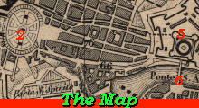
This map of Rome was included in an 1852 French Guide to Rome and it is based on a larger 1841 map by Paul-Marie Letarouilly (*); it shows Rome as it was before the development of railway and the 1870 annexation to the Kingdom of Italy; because it shows Rome in the last years of the Papal government, it is very useful to locate the monuments which house the papal coats of arms listed in the catalogue.


Map by Letarouilly
Map of Rome included in an 1852 French Guide to Rome

The map is split into 4 sections:
Quadrant 1 - NW - St. Peter's
Quadrant 2 - NE - Spanish Steps
Quadrant 3 - SW - Trastevere
Quadrant 4 - SE - St. John Lateran

The map can also be seen in a high resolution image (2300x1850 pixels) which has links to pages of this website showing all the monuments listed in the left section of the map.

(*) Paul-Marie Letarouilly (1795-1855) was a French architect and engraver who published in 1840-55 Édifices de Rome moderne, an extensive collection of etchings showing palaces, churches and other monuments of Modern Rome from the point of view of an architect.

Balustrade by Francesco Borromini in S. Carlo Borromini Balustrade by Francesco Borromini in S. Carlo Borromini Balustrade by Francesco Borromini in S. Carlo Borromini

SEE THESE PAGES DEALING WITH THE COATS OF ARMS OF THE POPES