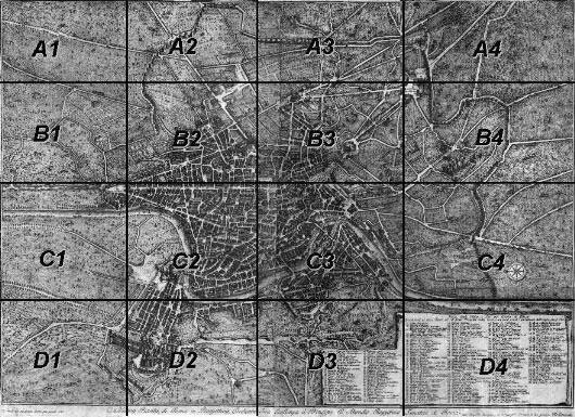
 The Map It is not a map in a technical sense, it is rather a bird's eye view with more than 300 points of interest clearly identified. The view is taken from the West, so top is East, left is North and right is South.
Section A1 - Villa Albani Section A2 - Porta Pia Section A3 - Porta S. Lorenzo Section A4 - S. Croce in Gerusalemme Section B1 - Villa Giulia Section B2 - Trinità de' Monti Section B3 - Palazzo del Quirinale Section B4 - Terme Antoniane Section C2 - Porto di Ripetta Section C3 - Isola Tiberina Section C4 - Porta S. Paolo Section D1 - Porta Angelica Section D2 - S. Pietro Section D3 - Porta S. Pancrazio From each section you can then reach Vasi's etchings showing the monuments of that section. Note: sections C1 and D4 do not show any remarkable sites. The 1781 map by Giuseppe Vasi shows most of the monuments of Rome, but not all of them. See the list of links to pages showing monuments not mentioned in the map.
You may wish to see the 1852 Map of Rome by P. Letarouilly. 
Go to my Home Page on Baroque Rome or to my Home Page on Rome in the footsteps of an XVIIIth century traveller. 
See the latest additions! |
All images © by Roberto Piperno. Write to romapip@quipo.it. Text edited by Rosamie Moore.
