

What's New!
Detailed Sitemap
All images © by Roberto Piperno, owner of the domain. Write to romapip@quipo.it. Text edited by Rosamie Moore.
Page added in December 2013.
|

 - On the Road to Petra - On the Road to Petra
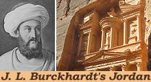
(left: J. L. Burckhardt in Arab attire in a XIXth century engraving; right: the Treasury of Petra)
If you came to this page directly you might wish to read an introductory page to this section first.
July 14th, 1812 - At the end of six hours and a half (from a Bedouin encampment near Madaba) we reached the banks of the Wady Modjeb, the Arnon of the Scriptures, which divides the province of Belka from that of Kerek, as it formerly divided the small kingdoms of the Moabites and the Amorites.
J. L. Burckhardt - Travels in Syria and the Holy Land - 1822
(left) Map showing the locations covered in this page (blue dots); (right) Wadi al-Mawjib (Wady Modjeb)
The view which the Modjeb presents is very striking: from the bottom, where the river runs through a narrow stripe of verdant level about forty yards across, the steep and barren banks arise to a great height, covered with immense blocks of stone which have rolled down from the upper strata, so that when viewed from above, the valley looks like a deep chasm, formed by some tremendous convulsion of the earth, into which there seems no possibility of descending to the bottom; the distance from the edge of one precipice to that of the opposite one, is about two miles in a straight line.
Wadi al-Mawjib (northern side)
We descended the northern bank of the Wady by a foot-path which winds among the masses of rock, dismounting on account of the steepness of the road, as we had been obliged to do in the two former valleys which we had passed in this days march; this is a very dangerous pass, as robbers often waylay travellers here, concealing themselves behind the rocks, until their prey is close to them. Upon many large blocks by the side of the path I saw heaps of small stones, placed there as a sort of weapon for the traveller, in case of need. No Arab passes without adding a few stones to these heaps. There are three fords across the Modjeb, of which we took that most frequented. I had never felt such suffocating heat as I experienced in this valley, from the concentrated rays of the sun and their reflection from the rocks. (..) We did not meet with any living being in crossing the Wady. Near the ruins is another heap of broken columns, like those on the opposite bank of the river; I conjecture that the columns were Roman milliaria (of Via Traiana, the road opened by Emperor Trajan from Syria to the Red Sea), because a causeway begins here, and runs all the way up the mountain, and from thence as far as Rabba; it is about fifteen feet broad, and was well paved, though at present in a bad state.
Ruins of ar-Rabbah: Temple with two niches which housed statues of Emperors Diocletian and Maximian
July 15th - At two hours and a half is Rabba, probably the ancient Rabbath Moab, where the ancient causeway terminates. The ruins of Rabba are about half an hour in circuit, and are situated upon a low hill, which commands the whole plain. I examined a part of them only, but the rest seemed to contain nothing remarkable. On the west side is a temple, of which one wall and several niches remain, by no means distinguished for elegance. Near them is a gate belonging to another building, which stood on the edge of a Birket (cistern/pond).
Ruins of ar-Rabbah: (left) another building; (right) Corinthian column
Distant from these ruins about thirty yards stand two Corinthian columns of middling size, one higher than the other.
In the plain, to the west of the Birket, stands an insulated altar. In the town many fragments are lying about. (..). There are many remains of private habitations, but none entire.
From seals found at Mamfis it appears that ar-Rabbah (or Areopolis) was a Nabatean town before being annexed to the Roman Empire in 106 AD. During the reign of Diocletian it became a fortified site which was part of a defensive system known as Limes Arabicus (Arabian fortified border). It housed a garrison of Mauri Illyriciani cavalrymen (Moors who were previously stationed in Illyricum, the western part of the Balkan peninsula - they are portrayed in Trajan's Column in Rome).
Castle of Kerak and part of the town to its right
At the end of five hours we entered a mountainous district, full of Wadys; and after a march of six hours we reached the town of Kerek.(..) The town of Kerek, a common name in Syria, is built upon the top of a steep hill, surrounded on all sides by a deep and narrow valley, the mountains beyond which command the town. (..) At the west end of the town stands a castle, on the edge of a deep precipice over the Wady Kobeysha.
(left) Castle of Kerak: walls of the Crusader (left, darker and more roughly built) and Mameluke (right) periods; (right) one of the defensive towers of the town
The town is surrounded by a wall, which has fallen down in several places; it is defended by six or seven large towers, of which the northern is almost perfect, and has a long Arabic inscription on its wall, but too high to be legible from the ground; on each side of the inscription is a lion in bas-relief, similar to those seen on the walls of Aleppo and Damascus. The town had originally only two entrances, one to the south and the other to the north; they are dark passages, forty paces in length, cut through the rock. An inscription on the northern gate ascribes its formation to Sultan Seyf-eddin (Saif ad-Din Qutuz, Mameluke Sultan 1259-60). Besides these two gates, two other entrances have been formed, leading over the ruins of the town wall.
Castle of Kerak: (left) underground passage; (right) kitchens
It is built in the style of most of the Syrian castles, with thick walls and parapets, large arched apartments, dark passages with loopholes, and subterraneous vaults; and it probably owes its origin, like most of these castles, to the prudent system of defence adopted by the Saracens against the Franks during the Crusades. In a large Gothic hall are the remains of paintings in fresco, but so much defaced that nothing can be clearly distinguished. Kerek having been for some time in the hands of the Franks, this hall may have been built at that time for a church, and decorated with paintings.
The Castle of Kerak was built by the Crusaders in 1142 to strengthen their control over the region which was almost unpopulated, but important because it was crossed by the pilgrim route to Mecca. It became the residence of the Crusader Lord of Oultrejourdain (Transjordan), a vassal to the King of Jerusalem. Raynald of Châtillon, former Prince of Antioch, became Lord of Oultrejourdain by marriage in 1177. His repeated attacks on caravans to Mecca led eventually to an all out war between Saladin, Sultan of Syria and Egypt and the Kingdom of Jerusalem. In 1187 at the Battle of Hattin, near Tiberias, King Guy of Lusignan and Raynald were taken prisoner and the latter was personally beheaded by Saladin. In 1189 Kerak was sieged and captured. The castle was almost entirely rebuilt by Baibars, the Mameluke Sultan who eradicated the Crusader presence in the Holy Land in 1291. You might wish to see some Crusader castles in the Levant which have retained most of their original appearance.
Castle of Kerak: ancient materials utilized in the construction of the castle: (left) a capital; (right) a funerary relief portraying a Nabatean cavalryman
Burckhardt was very unhappy with the behaviour of the Sheikh (governor) of Kerak:
(July 15th) - I thought it expedient to pay a visit of ceremony to the Sheikh, in order to deliver my letter; I soon however had reason to repent: he received me very politely; but when he heard of my intention of proceeding southward, he told me that he could not allow of my going forward with one guide only, and that as he was preparing to visit the southern districts himself, in a few days, I should wait for him or his people to conduct me.
I remained therefore at Kerek for twenty successive days, changing my lodgings almost every day, in order to comply with the pressing invitations of its hospitable inhabitants.
His secretary then informed me, that it was expected I should make some present to the Sheikh, and pay him, besides, the sum which I must have given for a guide. (..) Our negotiations on this point lasted for several days; when seeing that I could obtain no guide without an order from the Sheikh, I at last agreed to pay fifteen piastres for his company as far as Djebel Sherah.
(August 6th) As I thought that I had settled matters with him, to his entire satisfaction, I was not a little astonished, when he took me aside in the evening to announce to me, that unless he received twenty piastres more, he would not take charge of me any farther. Although I knew it was not in his power to hinder me from following him, and that he could not proceed to violence without entirely losing his reputation among the Arabs, for ill-treating his guest, yet I had acquired sufficient knowledge of the Sheikhs character to be persuaded that if I did not acquiesce in his demand, he would devise some means to get me into a situation which it would have perhaps cost me double the sum to escape from; I therefore began to bargain with him; and brought him down to fifteen piastres.
(..) Being satisfied that my cash was reduced to a few piastres, he began his plans for stripping me of every other part of my property which had excited his wishes. The day after his oath, when we were about to depart from Ayme, he addressed me in the presence of the whole company, saying that his saddle would fit my horse better than my own did, and that he would therefore change saddles with me. Mine was worth nearly forty piastres, his was not worth more than ten. I objected to the exchange, pretending that I was not accustomed to ride upon the low Bedouin saddle; he replied, by assuring me that I should soon find it much more agreeable than the town saddle. (..) I at last reluctantly complied; but the Sheikh was not yet satisfied: the stirrups he had given me, although much inferior to those he had taken from me, were too good in his eyes, to form part of my equipment. In the evening his son came to me to propose an exchange of these stirrups against a pair of his own almost unfit for use, and which I knew would wound my ankles, as I did not wear boots; but it was in vain to resist. The pressing intreaties of all my companions in favour of the Sheikhs son lasted for two whole days; until tired at length with their importunity, I yielded, and, as had expected, my feet were soon wounded.
(August 11th) The Sheikh of Kerek had come thus far, in order to settle a dispute concerning a colt which one of the Hamyde of Beszeyra demanded of him. We found here a small encampment of Howeytat Arabs, to one of whom the Sheikh recommended me: he professed to know the man well, and assured me that he was a proper guide. We settled the price of his hire to Cairo, at eighty piastres; and he was to provide me with a camel for myself and baggage. This was the last friendly service of Sheikh Youssef towards me, but I afterwards learnt, that he received for his interest in making the bargain, fifteen piastres from the Arab, who, instead of eighty, would have been content with forty piastres.
View westwards from the Castle of Kerak: in the distance the southern section of the Dead Sea
On the side towards the town the castle is defended by a deep fosse cut in the rock; near which are seen several remains of columns of gray and red granite. On the south side the castle hill is faced with stone in the same manner as at Aleppo, El Hossn (Krak des Chevaliers), Szalkhat (Salkhad, a castle in the Hauran region which was destroyed by the French in the 1920s), &c. (..) In the castle is a deep well, and many of the private houses also have wells, but their water is brackish; others have cisterns, which save the inhabitants the trouble of fetching their water from the Wady below.
(left) Al-Mazar - Mausoleum of the Battle of Mutah; (right) Shrine of Ja'far bin Abi Talib
The Battle of Mutah (629 AD), the most significant and fiercest battle fought against a Byzantine army during Prophet Mohammads lifetime, took place a few miles south of Kerak. The three leaders of the Muslim army (Zaid bin Harithah, Ja'far bin Abi Talib, and Abdullah bin Ruwahah ) all died in the fight. They were relatives or close friends of the Prophet. A modern mausoleum houses their shrines.
Khirbet et-Tannur
The name means "ruins on a hill (dark) as an oven". Because of its colour the mountain stands out from the whitish ridge of Wadi Al-Hasa. The ruins are those of a Ist century AD Nabatean open air temple where many statues portraying local deities were found in 1937 by Nelson Glueck, an American rabbi and archaeologist. These findings were a major contribution to understanding the Nabatean religion.
Dana Valley
August 13th - At the end of two hours and three quarters, direction S. we reached the top of the mountain, which is covered with large blocks of basalt. Here a fine view opened upon us; to our right we had the deep valley of Wady Dhana, with the village of the same name on its S. side; farther west, about four hours from Dhana, we saw the great valley of the Ghor, and towards the E. and S. extended the wide Arabian desert, which the Syrian pilgrims cross in their way to Medina. Dhana, which I suppose to be the ancient Thoana, is prettily situated, on the declivity of Tor Dhana, the highest mountain of Djebal, and has fine gardens and very extensive tobacco plantations.
In 1989 the valley was protected by the creation of the Dana Biosphere Reserve (you mignt wish to see their website - it opens in a separate window).
Castle of Shobak (or Shoubak or Showbak)
August 19th. In the morning I went to the castle of Shobak, where I wished to purchase some provisions. It was distant one hour and a quarter from the encampment, in a S.E. direction. Shobak, also called Kerek el Shobak, perhaps the ancient Carcaria, is the principal place in Djebel Shera; it is situated about one hour to the south of the Ghoeyr, upon the top of a hill in the midst of low mountains, which bears some resemblance to Kerek, but is better adapted for a fortress, as it is not commanded by any higher mountains.
Castle of Shobak: towers, one of which bears an inscription in large Kufic characters (you might wish to see a gigantic Kufic inscription at Diyarbakir)
The castle is of Saracen construction, and is one of the largest to the south of Damascus; but it is not so solidly built as the castle of Kerek.
The greater part of the wall and several of the bastions and towers are still entire.
The castle was built as Château de Montreal by the Crusaders in 1115 and it was their main fortress in the region until the construction of the Castle of Kerak. According to chronicles its countryside was farmed and its water mills processed sugar cane brought from the desert oases. The castle was rebuilt by the Mamelukes after it had been torn down by Saladin in 1189.
Castle of Shobak: (left) Mameluke bastion: (right) view westwards from an arrow-slit
The image used as background for this page shows an ancient relief at Shobak.
Move to:
Introductory Page
Ajlun Castle and Pella (May 3rd, 1812)
Amman and its environs (July 7th, 1812)
Aqaba
"Castles" in the Desert (incl. Qasr el-Azraq)
Jerash (May 2nd, 1812)
Madaba (July 13th, 1812)
Mt. Nebo and the Dead Sea (July 14th, 1812)
Petra (August 22nd, 1812)
Umm al-Jimal
Umm Qays (May 5th, 1812)

SEE THESE OTHER EXHIBITIONS (for a full list see my detailed index).
  
|


